Day Four: Lance Creek to Bag’s Creek Gap, 11.6 miles, 35.9 total AT miles.

Today started with a jolt at 5:01am. The rain was really coming down, a good, hard shower. I needed to get out of there quickly – and stay as dry as possible while doing so. My tent has a neat feature that allows the rainfly to stay up, while I stay dry underneath and pack up the tent and footprint.

I was also completely shocked that the inside of my tent stayed 100% dry and free from condensation – I’m really liking my REI Dash 2.

While retrieving my bear bag, I realized I was in a cloud – it was some of the thickest fog I’ve been in. My headlamp, switched to high, wasn’t even cutting through. I moved very slowly towards the trailhead.  

At 5:45, four of us left Lance Creek in the pouring rain and thick fog, attempting to go up and over Blood Mountain to Neel’s Gap 7.4 miles away. And under the assumption we had better book it. The last weather report put the storm hitting at 10:00.

We moved as quickly as possible, but goings were slow. An over abundance of caution went into every step. Again, very thankful I’m using trekking poles.

Thie hike out of Lance Creek was unbelievable – the conditions were terrible, the path, the Appalachian Trail, had turned into a stream. And we were heading straight up.


Half up Blood Mountain in the pouring rain.
 
Three off us ended up pushing ahead and making the summit just before 9:00. It was exhilarating. We sat in the shelter and ate a quick breakfast before moving on.

The descent was just as tricky. While the rain was starting to let up, the trail remained a muddy, flowing mess. I noticed that, despite my rain pants and gaiters, my feet were soaked.

  
Walking out of the woods and into Neel’s Gap was a truly amazing feeling. It was complete over-stimulation. I was drenched and hungry. I needed gear – my sleeping bag was drenched, not from my tent, but from a poor choice in stuff sack.

Neel’s Gap is home to Mountain Crossings Outfitters – the first proper chance a backpacker has to make gear exchanges and ship lesser choices back home. I went straight to the bathroom.

In a courtyard of sorts, hikers were coming in from the rainy night and morning and spreading gear about to better survey the damage.

I caught wind of a hiker box in the hostel downstairs. A hiker box is like a “take it or leave it” type place to drop off old gear and maybe find something nice. I was surprised at the stash laid out before me.

I grabbed a bag of trail mix while I hunted for a dry sack for the sleeping bag. No dice, but I did come across a brand new 1 liter Playpus. That officially solves my water storage problem, having acquired two in two days.

I spent little time in the outfitters, actually. I grabbed a new Black Diamond headlamp and a waterproof dry sack. In a addition to the free bag of trail mix, I bought a box of couscous and a refrigerator magnet.

It became apparent that most of the hikers coming in were calling it a day, opting to stay at the hostel. I really wanted to push on. One of the hikers who crossed Blood with me, “Savage”, wanted to continue as well. The third in our group, Alex, opted to stay behind.

Just as we were about to set off, “Mr. Cool-Aid” walked through the gap. He desperately wanted to push on as well. We were all visibly excited about taking our soaking wet bodies back into the woods.

You’ll notice at this point I’m using trail names. It’s no longer common to hear real names anymore. It’s weird how after just a few nights in the woods, a community starts to develop.

The three of us were approached by a section hiker, Brandon, who wanted to hike with us – his friend was suffering from a bad sunburn and was heading into town.

So the four of us headed off again, this time as a group, hoping for Whitley Gap Shelter 6.4 miles away, but willing to settle for anything reasonable along the way. We all agreed that we would stop at the last water source before Whitley.

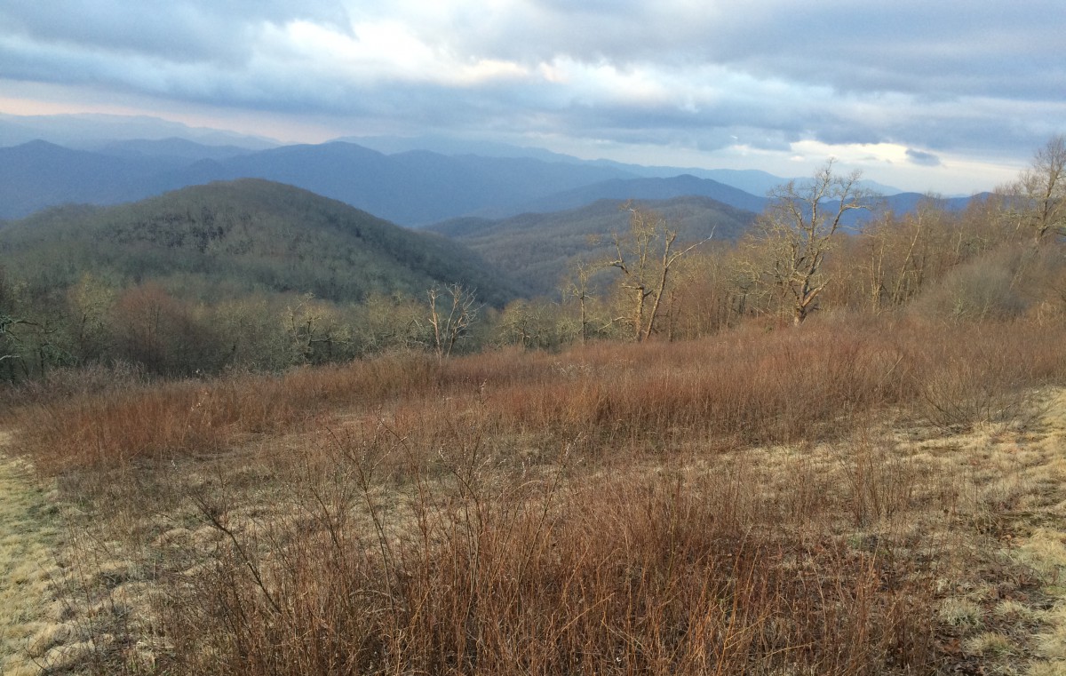
By the time we arrived at Bag’s Creek Gap to retrieve water, my feet were really starting to hurt – I could feel blisters forming under each of my big toes. But that really didn’t matter. While I was pondering the quality of the water supply, my hiking buddies were checking out the campsite on the other side of the trail.

it was nice, nice indeed! Nice view, good protection, established fire pit, and a strong breeze. The storms had passed and we had a clear night ahead. We immediately starting removing our tents and sleeping bags from our soaked packs, tying them to trees and letting the breeze do the rest.

Without much discussion, we decided to take advantage of the location and make camp. I pre-hung our bear bag while the rest started a fire. After setting up our tents, we ate like kings and mapped out the days ahead.

The clouds eventually passed and the stars came out. It was perhaps the perfect evening to what could have been a horrible day.

The plan for tomorrow is to make it close to Unicoi Gap, about 17 miles away. The three of us decided that a hot shower and a clean hotel is in order, so we booked a room in Hiawassee, GA. When we wake up the day after next, Wednesday, I guess, we’ll be a short 4 or so mile walk to Unicoi and a shuttle to the hotel.

I’ve learned not to assume that something will stay dry. And I’ve learned that camp shoes are a necessity. I left mine behind and am looking forward to seeing them in my mail drop next week.

I’m definitely in the market for another dry sack for my toiletries/first aid kit. I’ll also need new socks – and in multiple pairs. I was hoping to get at least 200 miles out of the Merrell’s I trained in, but I think it’s time for some new boots. I’ll probably grab a cheap pair of flip flops to tide me over until my camp shoes arrive.

Right now, I’m cautious about some hot spots on my feet that could lead to blisters if I’m not careful.

Another perk in Hiawassee is my ability to ship unnecessary gear home. I’ve already gathered up a few pounds of stuff that I can do without. It feels really good to be doing this.

And that thing happened that I’ve honestly been dreading. I got a trail name. I’m “Dad”. It’s not an age-related diss. I can think of a few friends of mine back home who would get a kick out of this. It apparently occurred to the group while I was making our hotel reservations.

That’s more than enough for tonight. I’ve got an early start tomorrow.

Note: I discovered the problem with posting pictures. The files are too large if I upload from my Sony – it’s like they time out. The app, even with spotty service, can handle a few iPhone pics. It’s my intention to post the higher quality photos when I have high-speed internet access once a week in town.

Blood Mountain Breakfast: dried figs

Lunch: sheer pound of free trail mix

Dinner: sheer pound of free trail mix, Israeli couscous with two packets of tuna, bacon, and oregano.

Dinner was delicious, but I won’t be buying tuna anymore. Incidentally, if you’re wondering if I’ve pooped in the woods yet, the answer is yes and with gusto.

Money: Mountain Crossings Outfitters $94.03 (headlamp, dry bag).

Day Three: Cooper Gap to Lance Creek, 12.2 miles / 24.3 total AT miles.

Note: My signal is too weak to upload photos. I’ll add them in later. They’re only alright anyway.

The shame of yesterday’s late start, coupled with my lack of water, drove me to pack up and leave camp at 6:30. I used my headlight to navigate for about 15 minutes and made it to the top of Justus Mountain in time for sunrise.

I made to the Justus Creek by 8:00 and took advantage of the fresh water by having a quick breakfast and scrubbing my face, neck and hands in my collapsable bowl. And then I was off again.

The trail was very nice today. I think I must’ve hiked these trails as a kid or in middle school – certain spots stood out very strongly in my memory.

After leaving Justus, I threw on the headphones and cranked out some miles arriving at the Gooch Mountain Shelter by 9:30. I’m surprised I enjoy listening to music so much while backpacking. It’s easier for me to find a hiking rhythm if there’s literally one playing in my head.

I didn’t really pass anyone on the trail or run into another hiker until reaching Gooch Gap, about 5 miles away from the day’s start.

It was here that I ran into what would become the first of many instances of “trail magic” – it’s where someone either mans a location, handing out free snacks and stuff OR sets up a cooler at a strategic spot and leaves the contents free for the taking.

At Gooch, I met “Slowride”, who offered some trail magic in the form of cookies and Mountain Lightning. That’s something else that I’m getting used to – trail names. Some folks start off, day one, with a name picked out for themselves. Other hikers have earned their name, often by doing something stupid along the way. Still others are given a name by another hiker. I’m biding my time.

My goal leaving Gooch was to catch a ride to a small outfitters in Suches, GA when I reached Woody Gap, 3.5 miles away. After enjoying the views at Ramrock Mountain, I was stopped by Dr. Pepper, a politely religious man who gave me a very generous bag of chocolate and candy.

Woody Gap was, by far, the busiest exchange I’ve had with non-hikers since starting. I was given a Sprite and then a brownie. It was great. Not seeing a shuttle, I started walking down the road towards Suches, about 2 miles away.

Within minutes, an employee of Woody Gap Outfitters picked me up in a giant cargo van and drove me the rest of the way.

I was able to remedy my water problem, at least temporarily – I bought their last Platypus 1 liter water bladder. I also grabbed a new dry bag for all by tech gear and some much needed sunscreen. While they do have a limited selection, it’s kinda refreshing to see that it’s all stuff you actually need, not stuff you think you need. I was dropped back at Wood about 45 minutes later and was given a coupon to stay at their hostel up trail.

Due to the bear canister situation ahead, I knew I needed to get to Lance Creek before the campsites filled up, as I was told they did yesterday.

I ended up finishing today’s hike with a guy who pulled off at Cooper Gap kinda late last night – it’s refreshing to know that, at any given time, there’s generally someone out there hiking your pace and to the same destination. You’ve just got ran ask around.

I arrived at Lance Creek and, sure enough, all the proper sites were taken. I’m camping on what I’d call a “hybrid” site. It’s a little bit trail, a little bit hill, but I fit.

A group of guys came in really late and had to set up way in the back of camp in what was previously the bathroom zone.

I had a nice hearty dinner and joked around with the few familiar faces I’ve run across. Of the group that left Amicalola three days ago and camped at Springer the first night, only a few of us are ready for Blood Mountain tomorrow. Most are at least a day back at this point. A few have even left the trail for good.

Tomorrow is gonna be a problematic. Thunderstorms are rolling in sometime between 10:00am and 2:00pm and Blood Mountain is 5 miles away. It’s actually supposed to start raining tonight. A small group of us have decided to wake super early and tackle this thing before the rain hits – or at least make it to one of two shelters and ride it out.

I spent the better part of half an hour this evening preparing my pack for all the rain tomorrow. I should be able to get up and go.

I’m still very excited to be out here, despite the forecast for tomorrow. It feels good to exercise hard like this. It feels good to have an amazing appetite at the end of the day. It’s fun trying to figure out the daily logistics of trail life – mileage, road crossings, campsites, etc.

The vast majority of the skills I’ve had to utilize since I got out here were largely theoretical when I started. I’m slowly figuring out how best to pack my pack and organize the pile of stuff I carry as well as other things.

My goal tomorrow is to reach Whitley Gap Shelter, about 14 miles away. Getting over Blood Mountain in the rain is gonna be tough.
I ate like a pig today.

Breakfast: one cup of dried cranberries and sunflower seeds, one bag of beef jerky

Snack (Gooch Gap): two chocolate chip cookies, one Mountain Lightning

Lunch: 5 mini chocolate bars, one flax seed bar, half cup of almonds (all gone now)

Snack (leaving Woody): one brownie and one Sprite

Dinner: pesto pasta with 2 Spam singles, half cup dried cranberries and sunflower seeds (all gone now), dried figs

Money: $19.47 for a one liter Platypus, small dry bag and some sunscreen for Woody Gap Outfitters.

Day Two: Springer Mountain Shelter to Cooper Gap, 12.1 miles/12.3 AT miles

I dozed off shortly after finishing last night’s post and woke up to some fairly heavy rain. I didn’t fully tighten the guylines that keep my rainfly taut and a little water got in on the storm side. Learned my lesson there, assuredly. For the most part, I slept well.

I was up at 6:15 and started repacking and organizing my backpack. I retrieved my food bag and made a hearty breakfast. I leisurely collected water and washed my face. I played around with my pack some more and before I knew it, it was 9:45.

I didn’t want to be in camp that late. I was excited to start hiking.

There were only a few camping options today – Hawk Mountain Shelter at 8 miles away or Gooch Mountain Shelter at nearly 16 miles.

I realized right away that my screwing around at camp potentially cost me about three hours of hiking time. There was no way I was going to make it to Gooch, but I didn’t think Hawk Mountain was far enough.

The hike to Hawk Mountain was nice, nothing too major. I inadvertently put some distance between myself and the hikers I left with that morning. I hiked alone most of the day. It was very, very nice.

It’s evident that spring still hasn’t arrived in North Georgia. The leaves, the trees, the trail – everything is a shade of brown. Hardwoods have yet to bud at the higher elevations. It looks like winter, but again I hiked in shorts and a t-shirt today.


Winter is still here, if in appearance only.
 
I made to it Hawk Mountain by 1:30, had a quick lunch and grabbed as much water as I could carry. An AT volunteer at Hawk confirmed that, if I were to leave, I wouldn’t run into water again until I hit Cooper Gap four miles away. He told me that the military keeps a tank of water at the pass and hikers are allowed to refill.
That little inside scoop was enough to send me 4 miles over Sassafras Mountain and into Cooper Gap – only to find this water barrel to be nonexistent. I set up camp with the sun setting and just enough water to get me to a stream two miles away when I wake up.


View from the top of Sassafras Mountain.
 
The weather was deceptively bright today. I got a sunburn. I bought one of those little sunscreen sticks thinking it would be enough to protect me until Spring officially arrives. I was completely wrong.

My legs still feel great, but my shoulders and neck hurt. My goal is to get up and outta here ASAP to get some delicious water. Full disclosure: I’m starting to reek.

Tomorrow, I’ll only be able to hike another 12 or so miles before hitting a “bear canister” zone. I should arrive early in the afternoon to tent near Lance Creek, the last stop before bear canisters become mandatory. They are only required for six miles, so I should be able to hike through the zone, no problem.

I really enjoyed the peace and quiet of hiking alone today. Tomorrow should be a little more crowded as the weekend is upon us and Blood Mountain awaits on Sunday.

Breakfast: one cup dark chocolate granola mixed with dried figs and almonds, served hot, with coffee

Lunch: beef jerky and almonds

Dinner: more couscous, kale and bacon, this time with Spam added in, and dried cranberries with sunflower seeds. More beef jerky.

Day One: Amicalola Falls State Park to Springer Mountain Shelter. 9.0 miles (0.2 AT miles)

This morning at 10:40am, I registered as hiker 534 at the Amicalola Falls Visitor Center, said my goodbyes to dad, and set off to attempt to hike the Appalachian Trail.

Passing through the arches at Amicalola. I look really short.

While Springer Mountain is the official southern terminus of the AT, nearly all northbound hikers register at Amicalola and hike the 8.8 mile approach trail to the summit of Springer for the official start.

Today’s hike started at the base of the falls and followed the approach trail north. It’s been a while since I’ve been in this part of the world and I miss it. Don’t get me wrong, the Cascades and Olympics in Washington are beautiful, but there’s something haunting about the North Georgia Mountains.

While the trees are still bare and dead leaves still litter the forest floor, the weather couldn’t be better. Shortly after reaching the top of the falls and making it a couple miles or so down the approach trail, the warm weather forced me into shorts and a t-shirt. It was a beautiful day with blue skies and a nice breeze ahead of this storm moving in.

As I stopped to eat lunch at a campsite just off the trail, I met another hiker and spent the afternoon trading leads as we worked our way towards Springer. Over the course of the approach trail, you gain about 2000 feet in elevation. It made for slow goings.
It’s gonna take some time getting used to having a 40 pound pack strapped to my back. There were some stretches during today’s hike that really forced me to slow down. I’m thankful I decided to hike with trekking poles – they really make a world of difference, especially when heading downhill.

I did run into a little snag with my water filtration system. My plan was to use a 96 oz Platypus collapsible water bag as my “dirty bag” and just filter the water from the Platypus into one of two water bottles that I carry for drinking and cooking only. After filling up at a stream before I left the falls, it didn’t take long to realize the that the Platypus had a hole on the seam. It went straight in the trashcan.

For the time being, I’m left with my two water bottles, one now taking the place of the dirty bag. If anything, it’s tedious – I’ll buy another bag soon.

Around 4:00, I reached the summit of Springer and was able to take my first official steps on the AT. And 0.2 miles later, I stopped for the night. While I felt I could have gone further, I really didn’t have any options with it already being so late in the afternoon.


Official southern terminus of the AT and the first of many white blazes leading the way.
 
I enjoyed the hike into camp. After a curious encounter with a hiker near the first set of campsites, I finally found my way down to the shelter and met a small group of AT hikers that had assembled there this evening – probably about 8 total.

I had just enough time to set up my tent, make dinner, hang my food bag, gather water and wash up before the sun went down.

The rest of my gear works great – I like my stove and made a pretty tasty dinner of couscous, fresh kale and bacon. I’ll probably do it again.

I’m trying to think of clever ways to make life a little easier on the trail. I’ve got my already funky socks hanging on the inside of the tent to dry them out, along with my camp towel and underwear, both airing out in this built-in mesh basket.

As for the upcoming days, bear canister regulations kinda force your hand as to how far you can hike before you hit Blood Mountain, the highest point on the AT in Georgia. For tomorrow, it looks like I’ll either have 8.1 miles to the Hawk Mountain Shelter or 15.8 miles to the Gooch Mountain Shelter – there’s unfortunately no stops in between.


View north from the summit of Springer.
 
I’ll just have to wait and see. I’m feeling good about this thing. I really couldn’t be happier. I’m thankful I trained before leaving, that’s for sure.

In keeping with the idea that I’d really like to keep as detailed an account as possible as to what I eat, how much I spend, etc., I figured I should just list all of that stuff towards the end of each entry.

Breakfast: port tenderloin biscuit

Lunch: 3.25 oz bag of teriyaki beef jerky, about 6 oz of Dot’s pretzels

Dinner: 4 oz almonds, couscous with bacon and kale (about 2 cups)

As I’m wrapping this up, about to start uploading photos, it’s starting to rain, nothing heavy, just a light Seattle-style shower. I didn’t think this was supposed to come in until tomorrow.

Less than a week away and other concerns.

I’m really glad I took this detour to Minot, ND to visit with my mom and stepdad before setting off for Atlanta and the Appalachian Trail, now less than a week away.


Ranch in Minot, ND as seen from my mom and stepdad’s backyard.
 
A week or so ago, I lamented the seemingly unending list of tasks that must be accomplished before I left Seattle – and for the most part, I’ve been eventually able to cross them off the list. I’m exhausted.

Over the past two weeks, I took an amazing trip around the Olympic Peninsula to say goodbye to the beautiful state of Washington (and a very dear friend). I worked out a nutrition plan to determine my caloric needs while hiking. I carefully packed away all my possessions and moved them into a storage unit. I spent too much time buying last-minute necessities from REI, Patagonia, North Face. I went to five different Walgreen’s over multiple days to stock up on cheap beef jerky and almonds for my mail drops. I worked a full schedule at Elliott’s until the very end. I handed over the keys to my apartment. And the whole time, I kept finding time to say goodbye to some of the important people I’ve met while living in Seattle. And then, quite literally, I hopped on a plane for Minot.


Ruby Beach is one of the most beautiful places I’ve ever visited.
 
I really haven’t had an opportunity to just sit, rest or really even think. It’s been go-go-go for some time now. So I’m thankful the folks have gone to bed and I’ve got a few minutes to check in here – and then tomorrow I fly from Minot to Minneapolis to Indianapolis to Atlanta before meeting up with all my old friends back home for dinner. I’m excited to go to Indianapolis. I really hope the 46 minutes I spend there treat me well.

Hopefully, when I’m not running from gate to gate tomorrow, I’ll be able to finish my gear list. It’s gotten quite long indeed. But everything fits in my pack with room to spare. This morning, I hopped on a scale to see how much my pack weighs (base weight only, so no food or water). It’s clocking in right at 25 pounds. I’ve read of folks going lighter, and I’m sure I could too (and probably will). But for now, and considering all the technology I’m bringing to keep up with this site, that weight will have to do. Just take it from me – I’m ready to go and I’m carrying some pretty cool stuff.

It’s been very hard saying goodbye to Seattle, if even temporarily. I’m sure it’ll be hard saying goodbye to my folks tomorrow as well as to all my friends and family in Atlanta over the upcoming week. It’s tough to just walk away like that. I suppose that nervousness I felt last week has given way to the very real acknowledgement that this thing is happening soon. I think I’m just anxious to make this idea of living and hiking on mountains my “new normal”. But again, those excited feelings don’t come without a pile of bittersweet goodbyes and a tinge of regret.

Over the next few days, when I’m not barbecuing or just regularly stuffing my face (gotta put on some pounds), I’ll be finalizing my mail drops and purchasing the few remaining bits of gear (knife, mace, fuel) that I didn’t want to travel with.

That brings up a good point. I suppose I should probably tackle the two questions I’m most frequently asked (besides Why?):

First, what about bears? Am I afraid of bears? Will bears eat my food? Will bears eat me?

Bears. It’s funny. I didn’t think about bears at all until folks started asking me about them. From what I can gather from past thru-hiking journals and online AT resources, I really don’t have to worry about bears. There is such a thing as “bear safety”, as ridiculous as that may sound. But I trust it.

Apparently the point is to not smell like food or act like an idiot. To combat these, I will hang my food every night and use my zoom lens. A titanium cup hangs from my pack and makes enough racket to alert bears to my presence. If I accidentally surprise a bear, I’m supposed to slowly back up and speak to it with an authoritative voice, even if it bluffs a charge at me. If all else fails, I’ll have the aforementioned knife and mace. I’m resourceful.

Which brings me to the second most-asked question: Are you carrying a gun? What about murderers and thieves on the trail?

Here’s the deal – I’m from Atlanta and I’ve been mugged. Would carrying my pistol then have prevented my mugging? Hell no! The dude jumped out and surprised me. I would have been caught with my pants down and could have paid the ultimate price. The same logic works on the trail. When I was mugged, I did have a gun at home and that didn’t help. Likewise, if I’m carrying on the trail, any piece would have to be carefully stowed away deep in my pack to keep it dry – if I need it in a pinch, I won’t be able to get to it.

And I’m not carrying a sidearm – I actually might want to meet like-minded individuals during this hike and visibly packing heat wouldn’t attract the kind of attention I’m looking for.

Caution is the key word. I generally know a con when I see one – again, I’m from Atlanta. And if all else fails, I’ll have the aforementioned knife and mace. I’m resourceful.

I’ve done my research and hope to act accordingly, to the best one can assume they’d act if they’ve read as much as I have anyway.

And there’s been many other questions – hopefully I’ll get a chance to ramble out some answers between eating, shopping and packing in the coming days. It’s late and I’ve got three planes to catch tomorrow. ‘Til next time.

Here we go.

After a few iterations, I’ve decided to get this website started again. In less than two weeks, I’ll be leaving Seattle to attempt a thru-hike of the Appalachian Trail.


A year ago, I decided to do this thing. It meant giving up on what I perceived to be a dead-end career in PR and refocusing my energy on what I hope will be a life-changing experience. It meant going back to waiting tables full-time and then some. It meant moving to smaller apartments. It meant saving my ass off and training just as hard.


I think I’m ready to go. The 2016 AT is 2,189.1 miles long, stretching from Springer Mountain in Georgia all the way to Mt. Katahdin in Maine. I’m hoping to kick this thing off on Wed, March 9 and finish in mid-August, five months later.


Starting next week, everything I own will go into a storage unit. Mail will be forwarded and bills will go on auto-pay. I saved enough to ensure I can attempt a thru-hike without breaking the bank at all. Barring minor purchases, I’m fully geared up, tip to tail.


It’s my intention to use this website to chronicle the whole thing. I purchased a Zagg foldable Bluetooth keyboard to turn my iPhone into a makeshift word processor. To power both, I bought a Ravpower 26800mAh external battery – it’ll charge my phone about 10 times before needing a recharge itself. I’m also bringing my Sony NEX-5T digital camera with a standard 16-50 lens and a 55-210 zoom, with extra rechargeable batteries. I’ve tested the whole thing out and should have no problem using the Sony app to upload photos and the WordPress app to update this blog – if I can get a cell signal, that is.


It’s my goal to provide daily updates – mileage, diet, elevation and all the other technical stuff that comes with backpacking in the Appalachians. I admit, it’s a major commitment. But it’s been done before, hundreds of times. I’ve followed sites like trailjournals.com for years just to read what it’s like to backpack one of America’s long trails.


Hiking the AT is a childhood dream come true – one that is now occupied with some very adult concerns. While I hesitate to set any sort of expectations regarding personal growth or whatever, I do remind myself that the simple act of hiking and camping on mountains is a good thing for the mind, body and soul.


Currently, I’m doing well. I’m excited and nervous at the same time – there’s a lot left to do here in Seattle before I leave. I don’t foresee updating this thing daily until I start the hike – I will add a “Gear” section soon.


I do want to say thank you to my family and friends for all the encouragement and support I’ve received lately. I’ve been asked some really great questions – mostly about bears. I’ve made a lot of really great friends here in Seattle, both at the 5 Spot and Elliott’s. I’ve fostered some close relationships with some truly amazing people. A year ago, I didn’t expect to be attached to so many when I left.


I am looking forward to spending some quality time with my mother and stepfather in Minot, ND before flying to Atlanta to see my father, sister, grandmother and the rest of my family and friends. And then I’m off.


It’s just right around the corner. I’ll do my best to update before I start – no promises. Thanks friendos.